A Framework of image processing and machine learning utilization for flood disaster management
DOI:
https://doi.org/10.24036/teknomekanik.v5i2.17372Keywords:
Disaster management, Image processing, Machine learning, Padang cityAbstract
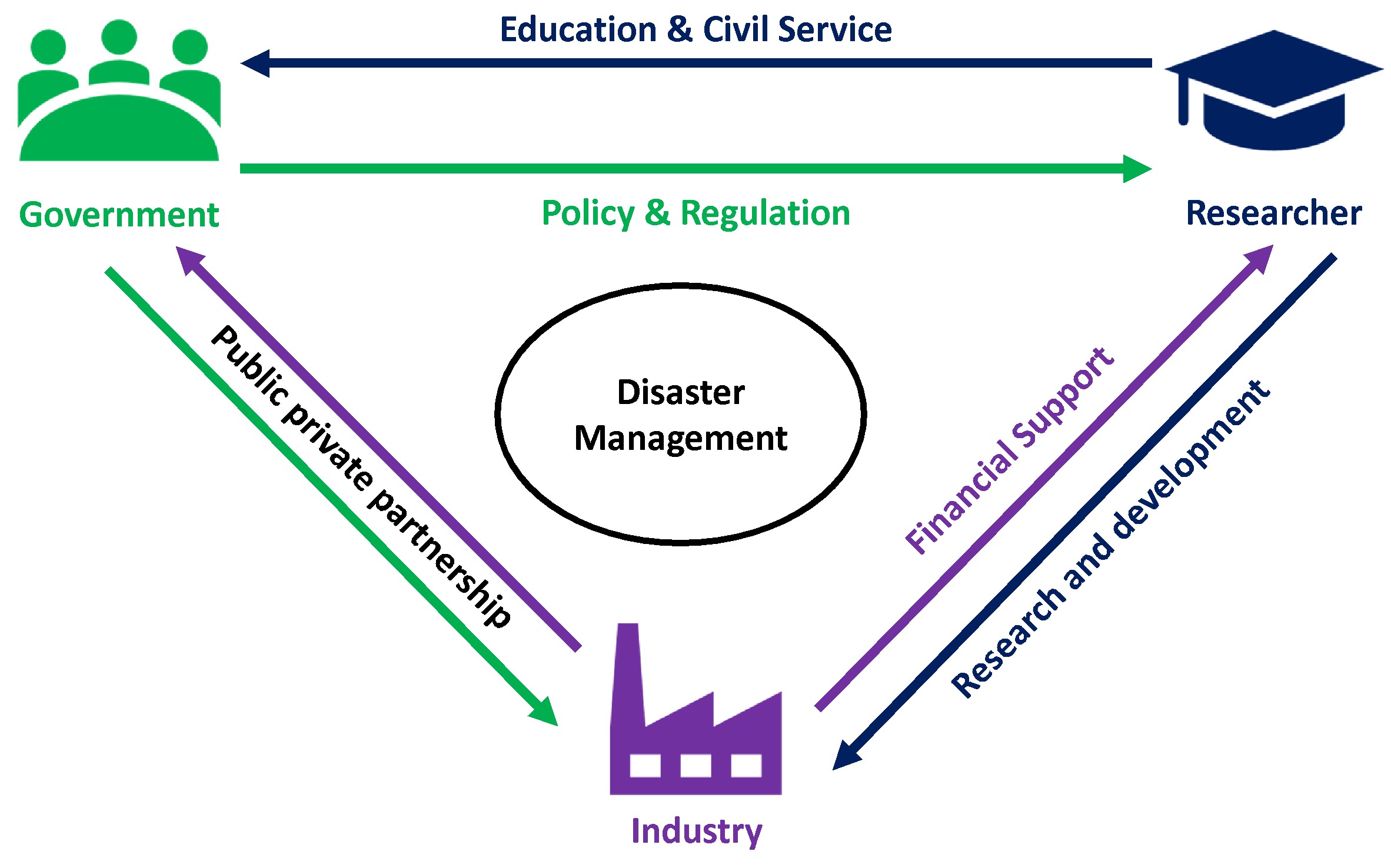
Flood is one of the annual disasters in many places. It has not been well-managed yet both pre-disaster and post-disaster. Image processing and machine learning are commonly utilized for disaster management systems such as forecasting any potential flood by monitoring the water level in rivers and dams. However, it has a limited framework to be implemented as a strategic plan in flood management. Thus, this study aims to develop a framework for image processing and machine learning utilization for flood management. This study involves Padang, West Sumatera, Indonesia as a sample. It was conducted in three stages; 1) categorize the strategic plans and policies; 2) gather relevant literature; 3) analyze data. As findings, this study proposes a framework consisting of enhanced disaster preparedness, improved coping capacity, and completion of post-disaster reconstruction and rehabilitation. Involvement of the government, researchers and industry are mandatory. Government and researchers should collaborate to establish policies and regulations. Researchers should conduct studies with financial support from the industry. Meanwhile, the industry should be a public-private partnership with the government. In addition, the involvement of the private sector and the government are important factors that must exist to support research in this field.
References
S. Sankaranarayanan, M. Prabhakar, S. Satish, P. Jain, A. Ramprasad, A. Krishnan, Flood prediction based on weather parameters using deep learning, J. Water Clim. Change 11 (2020) 1766–1783, https://doi.org/10.2166/wcc.2019.321.
G.K. Wedajo, LiDAR DEM data for flood mapping and assessment; opportunities and challenges: a review, J. Rem. Sens. GIS 06 (2017) 2015–2018, https://doi.org/10.4172/2469-4134.1000211.
M. Rivas Casado, T. Irvine, S. Johnson, M. Palma, P. Leinster, The use of unmanned aerial vehicles to estimate direct tangible losses to residential properties from flood events: a case study of Cockermouth following the Desmond storm, Remote Sens. 10 (2018) 1548, https://doi.org/10.3390/rs10101548.
L. Hashemi-Beni, J. Jones, G. Thompson, C. Johnson, A. Gebrehiwot, Challenges and opportunities for UAV-based digital elevation model generation for flood-risk management: A case of princeville, north carolina, Sensors (Switzerland). 18 (2018), https://doi.org/10.3390/s18113843.
G. Schumann, Preface: remote sensing in flood monitoring and management, Remote Sens. 7 (2015) 17013–17015, https://doi.org/10.3390/rs71215871.
N.M. Robertson, T. Chan, Aerial image segmentation for flood risk analysis, in: 2009 16th IEEE International Conference on Image Processing (ICIP), IEEE, 2009, pp. 597–600, https://doi.org/10.1109/ICIP.2009.5413865.
M.A. Witherow, C. Sazara, I.M. Winter-Arboleda, M.I. Elbakary, M. Cetin, K.M. Iftekharuddin, Floodwater detection on roadways from crowdsourced images, in: Computer Metehods in Biomechanics and Biomedical Engineering: Imaging & Visualization 7, 2019, pp. 529–540, https://doi.org/10.1080/ 21681163.2018.1488223.
M. Rahnemoonfar, R. Murphy, M.V. Miquel, D. Dobbs, A. Adams, Flooded area detection from uav images based on densely connected recurrent neural networks, in: IGARSS 2018–2018 IEEE International Geoscience and Remote Sensing Symposium, IEEE, 2018, pp. 1788–1791, https://doi.org/10.1109/ IGARSS.2018.8517946.
M.R. Rahman, P.K. Thakur, Detecting, mapping and analysing of flood water propagation using synthetic aperture radar (SAR) satellite data and GIS: a case study from the Kendrapara District of Orissa State of India, Egypt. J. Remote Sens. Space Sci. 21 (2018) S37–S41, https://doi.org/10.1016/j.ejrs.2017.10.002.
M. Rahman, N. Chen, A. Elbeltagi, M.M. Islam, M. Alam, H.R. Pourghasemi, W. Tao, J. Zhang, T. Shufeng, H. Faiz, M.A. Baig, A. Dewan, Application of stacking hybrid machine learning algorithms in delineating multi-type flooding in Bangladesh, J. Environ. Manag. 295 (2021) 113086, https://doi.org/10.1016/j.jenvman.2021.113086.
Pregnolato, A. Ford, S.M. Wilkinson, R.J. Dawson, The impact of flooding on road transport: a depth-disruption function, Transp. Res. Part D: Transp. Environ. 55 (2017) 67–81, https://doi.org/10.1016/j.trd.2017.06.020.
D. Popescu, L. Ichim, T. Caramihale, Flood areas detection based on UAV surveillance system, in: 2015 19th International Conference on System Theory, Control and Computing (ICSTCC), IEEE, 2015, pp. 753–758, https://doi.org/10.1109/ICSTCC.2015.7321384.
D. PANAGOULIA, Artificial neural networks and high and low flows in various climate regimes, Hydrol. Sci. J. 51 (2006) 563–587, https://doi.org/10.1623/hysj.51.4.563.
Y.-T. Lin, M.-D. Yang, J.-Y. Han, Y.-F. Su, J.-H. Jang, Quantifying flood water levels using image-based volunteered geographic information, Remote Sens. 12 (2020) 706, https://doi.org/10.3390/rs12040706.
N. Nirupama, S.P. Simonovic, Increase of flood risk due to urbanisation: a Canadian example, Nat. Hazards 40 (2007) 25–41, https://doi.org/10.1007/s11069-006-0003-0.
J. Ryu, E.J. Yoon, C. Park, D.K. Lee, S.W. Jeon, A flood risk assessment model forcompan ies and criteria for governmental decision-making to minimize hazards, Sustainability 9 (2017) 2005, https://doi.org/10.3390/su9112005.
R. De, O. Werneck, I.C. Dourado, S.G. Fadel, S. Tabbone, R. Da, S. Torres, Graph-based early-fusion for flood detection, in: 2018 25th IEEE International Conference on Image Processing (ICIP), IEEE, 2018, pp. 1048–1052, https://doi.org/10.1109/ICIP.2018.8451011.
R.W. Tiner, M.W. Lang, V.V. Klemas, Remote Sensing of Wetlands, CRC Press, 2015, https://doi.org/10.1201/b18210.
T. Nguyen, J. Han, D.-C. Park, Satellite image classification using convolutional learning, in: AIP Conference Proceedings, 2013, pp. 2237–2240, https://doi.org/10.1063/1.4825984.
S. Frigerio, L. Schenato, G. Bossi, M. Mantovani, G. Marcato, A. Pasuto, Hands-on experience of crowdsourcing for flood risks. An android mobile application tested in Frederikssund, Denmark, Int. J. Environ. Res. Public Health 15 (2018) 1926, https://doi.org/10.3390/ijerph15091926.
O. Kis¸i, A combined generalized regression neural network wavelet model for monthly streamflow prediction, KSCE J. Civ. Eng. 15 (2011) 1469–1479, https://doi.org/10.1007/s12205-011-1004-4.
X. Lu, B. Mao, B. Dong, Comment on “an efficient and stable hydrodynamic model with novel source term discretization schemes for overland flow and flood simulations” by Xilin Xia et al, Water Resour. Res. 54 (2018) 621–627, https://doi.org/10.1002/2017WR021563.
T. Nguyen, J. Han, D.-C. Park, Satellite image classification using convolutional learning, in: AIP Conference Proceedings, 2013, pp. 2237–2240, https://doi.org/10.1063/1.4825984.
J. Fern´andez-Hernandez, D. Gonz´alez-Aguilera, P. Rodríguez-Gonz´alvez,J. Mancera-Taboada, Image-based modelling from unmanned aerial vehicle(UAV) photogrammetry: an effective, low-cost tool for archaeological applications, Archaeometry 57 (2015) 128–145, https://doi.org/10.1111/arcm.12078.
K. Sowmya, C.M. John, N.K. Shrivasthava, Urban flood vulnerability zoning of Cochin City, southwest coast of India, using remote sensing and GIS, Nat. Hazards 75 (2015) 1271–1286, https://doi.org/10.1007/s11069-014-1372-4.
S. Supratid, T. Aribarg, S. Supharatid, An integration of stationary wavelet transform and nonlinear autoregressive neural network with exogenous input for baseline and future forecasting of reservoir inflow, Water Resour. Manag. 31(2017) 4023–4043, https://doi.org/10.1007/s11269-017-1726-2.
Downloads
Published
Issue
Section
License
Copyright (c) 2022 Fazrol Rozi, Indri Rahmayuni, Ardi Syawaldipa, Fitri Nova, Primawati Primawati, Batara Batara (Author)

This work is licensed under a Creative Commons Attribution 4.0 International License.
How to Cite
Share